Summary
- Specify one or two nav targets.
- Measure distance and measure bearing from any flight point to the nav targets
- Display a vector from the aircraft to the targets.
Latitude and Longitude
The Nav panel displays the current location of the aircraft in two formats. Decimal format specifies the latitude and longitude as signed numbers. Deg-Min specifies the latitude and longitude as DDMM where DD is degrees and MM is minutes, plus a prefix letter specifies N or S for the latitude and W or E for the longitude.
For example, the following are equal:
|
|
decimal format: |
LAT: 42.54650 LON: -74.68233 |
|
|
Deg-Min-Sec format: |
LAT: N 4232.79 LON: W 7440.94 |
Specifying Navaid Targets
You can specify up to two navigation targets, and have the system display the 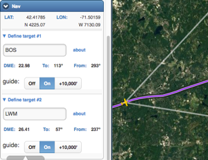 distance and bearing from the current aircraft location to or from the targets.
In the flight on the right, the pilot was required to intercept BOS-330, then hold north-west of the intersection with LWM-260. The NAV tool in the picture shows the plane on the BOS-327 radial.
To specify a target, type it in one of the two target boxes. You can specify targets in any of the formats below:
|
Target Type |
Examples |
Description |
|
decimal coordinates |
42.345 -70.3791 42.345, -70.3791 |
Enter the latitude and longitude in decimal format, with or without a comma in between. |
|
DMS coordinates |
N4216.16 W12544 N4216.16, W12544 |
Enter the latitude and longitude in Deg-Min format, with or without a comma in between. Spaces after the N/S/E/W designators are optional. |
|
VOR |
GDM |
Enter the three-letter code for the VOR. |
|
Localizer |
I-BED |
Enter the code for the localizer. |
|
Any fix name |
OYIVE |
Enter the code for the fix. |
For visualization, you can also draw a vector, called guide from the aircraft to the target. To draw, tap “On”. When in 3D mode you can also tap “10,000” to display a guide between points 10,000′ above the target and the aircraft.